
Civil Parish: Cashel
Barony: Rathcline
County: Longford
Province: Leinster
The Parish of Cashel is situated in the south of County Longford.
It could be described as an island parish, fertile farmland surrounded by bogland to the North and East, with Lough Ree and the river Shannon to the South and West.
Cashel has an area of 89.7 km² / 22,155.8 acres / 34.6 square miles, and consists of 76 townlands, this represents 72.3% of all the area in Cashel.
The village is Newtowncashel, in the townland of Cornadowagh or ‘Cor na Dumhca’ ás Gaeilge, meaning the ‘Round Hill of the Cauldron’.
Important historical sites in the parish are ‘Inis Clothrann’ or ‘Quakers Island’ where St. Diarmuid founded an abbey in the year 540 AD, and ‘Saints’ Island’ where St. Kevin founded a monastery in 544 AD.
The ruins of the old parish church St. Catherine’s and its adjoining cemetery sit on the side of Cashel Hill overlooking Lough Ree.
It boasts an extensive shoreline along Lough Ree, with Barley Harbour listed as the only harbour in Co. Longford.
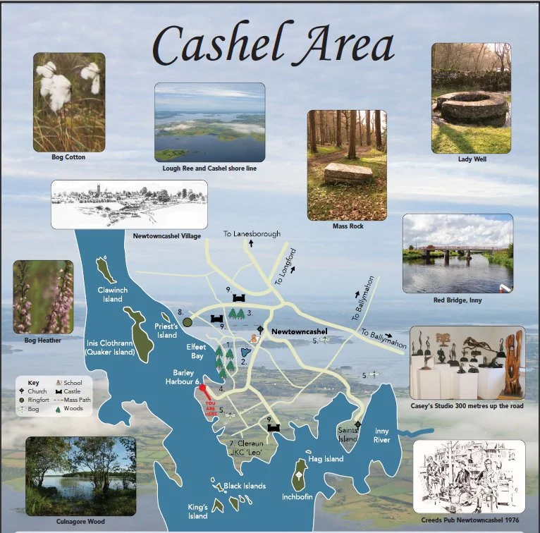
Islands of Cashel and Lough Ree
Lough Ree is the second largest lake on the river Shannon, it should come as no surprise to learn that many of the islands sustained small populations of inhabitants right up to modern times. The island people of Lough Ree needed to be a hardy race. They maintained a living through fishing and farming. There was nothing romantic about life on the islands – the reality of island life was tough. These small communities were frequently cut off from the mainland for long stretches during the winter. They were cut off from shops, schools and pubs; they were deprived of the services church and state and often were unable to get medical assistance. Their means of travel was an open boat with sprit-sail and oars and the transport of livestock was a precarious business. Twelve of Lough Ree’s fifty two islands are located within the parish of Cashel.
The largest and most historic island on the River Shannon is Inis Clothrann. The name Clothra was the name of Queen Maeve’s sister and two landmarks on the island are Grianan Meidhbhe and Innod Marfe Meidhbhe. St Diarmuid founded a monastery on this island about the year 540 AD and the well preserved ruins are to be seen in the area known as ‘The Moat’.
On Saint’s Island can been seen the ruins of an Augustinian Monastery that survived up to the time of the suppression of the monasteries in the reign of Henry the VIII. Its most famous son was Augustine McGradion who compiled the Annals of All Saints here in the 15th century. This historic island can now be approached by a causeway.
In 2023, the National Parks and Wildlife Service (NPWS) purchased the Black Islands as a strategic investment in nature conservation.
The works carried out, removed scrub to protect grasslands that endangered species such as curlew, lapwing, redshank, oystercatcher and other vulnerable wading birds need for nesting and foraging. Other waterbirds of national significance such as common scoter, gadwall and common tern also use the lake as a breeding site and will benefit from these works. Common tern are vulnerable to fluctuating lake levels as they nest on island shorelines and spits.
listing from North to South
Clawinch
Priest’s Island
Saint’s Island
Inchclearaun (Inis Clothrann / Quaker )
The Black Islands
Brearoge Islands
Horse Island
Sand Island
Girls’ Island
Kings Island
Nuts Island
Red Island
Long Island
Barley Harbour
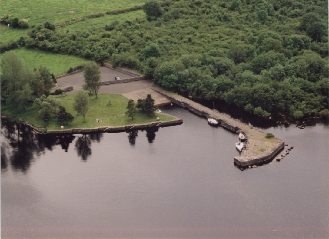
Barley Harbour, a fine cut-stone harbour, offers safe mooring for boats along this lakeshore. The harbour also boasts a slipway for launching boats and has benches and lovely grassy areas for picnics, making it a perfect location for boating and swimming.
Also, very close by is the workshop and studio of famous sculptors, Michael and Kevin Casey, who create sculptures in Bog Wood, many examples of which can be seen throughout the village.
Castles
Five castles are recorded in the parish of Cashel – Elfeet, Caltramore, Corool, Portanure and the castle of Baile Nui ( Newtown).
The ruins of Elfeet Castle can still be seen. George Calvert, the owner of a small 15th century tower house, became governor of Maryland, USA and founder of the city of Baltimore.
Tradition has it that it was from this castle that Forby flung the stone that killed Queen Maeve on Inis Clothrann Island.
There are still some remains to be seen of Corool and Portanure Castles.
John Keegan Casey (Leo) 1836 – 1870
“‘Oh then tell me, Sean O’Farrell, tell me why you hurry so?’
‘Hush, a bhuachaill, hush and listen,’ and his cheeks were all a-glow’
‘I bear orders from the Captain, get you ready quick and soon
For the pikes must be together at the rising of the moon’.”
This poem, ‘The Rising of the Moon’ was written by the boy poet at the age of fifteen years and is known and sung throughout the English speaking world.
‘Leo’ Casey taught school here at Cleraun and many of his beautiful poems were written here.
They include ‘ A Boating on Lough Ree’ and ‘Maire My Girl’. Tragically, he died at the young age of twenty-four.
Lough Slawn and Meadows
Located just a short distance from the village is the lovely Lough Slawn which is surrounded by meadows and bog lands.
This lake provides the local or the visitor the opportunity to take a leisurely stroll around its shore and to discover the richness of the bog plants and flowers.
Lady Well and Mass Rock
Lady Well is situated in the townland of Derrydarragh.
It is still visited by some people between the two Lady Days of the 15th August and on the 8th September.
No one knows how far back the pilgrimage to Our Lady’s Well goes but up to 1887 the 9th of September was a Holy Day of obligation in the parish of Cashel and a famous Pattern Day was frequented by people from near and far.
During the dark days of the Penal Times, the good people of Cashel had neither church nor chapel, but were compelled to assemble for worship under the broad dome of heaven.
It is no accident that one of the Mass rocks is situated very close to Lady Well, where it can still be seen in Derrydarragh.
At the other end of the parish, in Derryhaun, there is another Mass Rock close to the edge of the bog.
Culnagore Wood
Culnagore Wood (Wood of the Oak) consists of ancient woodland and covers and area of 90 acres along the edge of Lough Ree.
It contains many fine species of woodland flowers and at the northern end there is a colony of Garden warblers, a small secretive bird rarely found or seen in Ireland.
The wood is the perfect place for amblers and walkers who can enjoy its peace and tranquility.
Carrowmore Wood
This state forest of pine and spruce is on the highest hill in the parish.
Along its edge is to be found the mass pathway once used by the people of Elfeet and Cashel to go to and from Mass.
Larger than Culnagore Wood, this wood also hugs the shore of Lough Ree and provides a wonderful place for long walks or leisurely strolls.
Cashel Commons (The Ranch)
This area is commonage covering approximately 200 acres of pasture and scrubland.
It boasts easy walking routes which were formed by the movements of horses and sheep and affords the visitor magnificent views of Lough Ree.
A wonderful array of bluebells is to be found here in spring in the Hazel Woods.
Two well-preserved ringforts are also here and are of antiquarian interest.
Raised Bogs
Raised bogs are discreet, raised, dome-shaped masses of peat occupying former lakes or shallow depressions in the landscape.
They occur throughout the midlands of Ireland. Their principal supply of water and nutrients is from rainfall and the substrate is acid peat soil, which can be up to 12m deep.
Raised bogs are characterised by low-growing, open vegetation dominated by mosses, sedges and heathers, all of which are adapted to waterlogged, acidic and exposed conditions.
They occur on land below 130m and in that climatic zone where rainfall is between 800 and 900mm per year.
Raised bogs began to develop 10,000 years ago in depressions occupied by shallow lakes in which anaerobic conditions occurred.
Complete decomposition of plant material is prevented. In time this un-decomposed plant material forms a thick layer of peat that rises towards the surface of the lake.
Eventually the surface peat is invaded by sedges to form a fen. The fen peat layer thickens so that the roots of plants growing on the surface are no longer in contact with the calcium-rich groundwater. The only source of minerals for plants is now rainwater, which is very poor in minerals. Raised bog species, such as Sphagnum mosses begin to invade and eventually the fen becomes a raised bog.
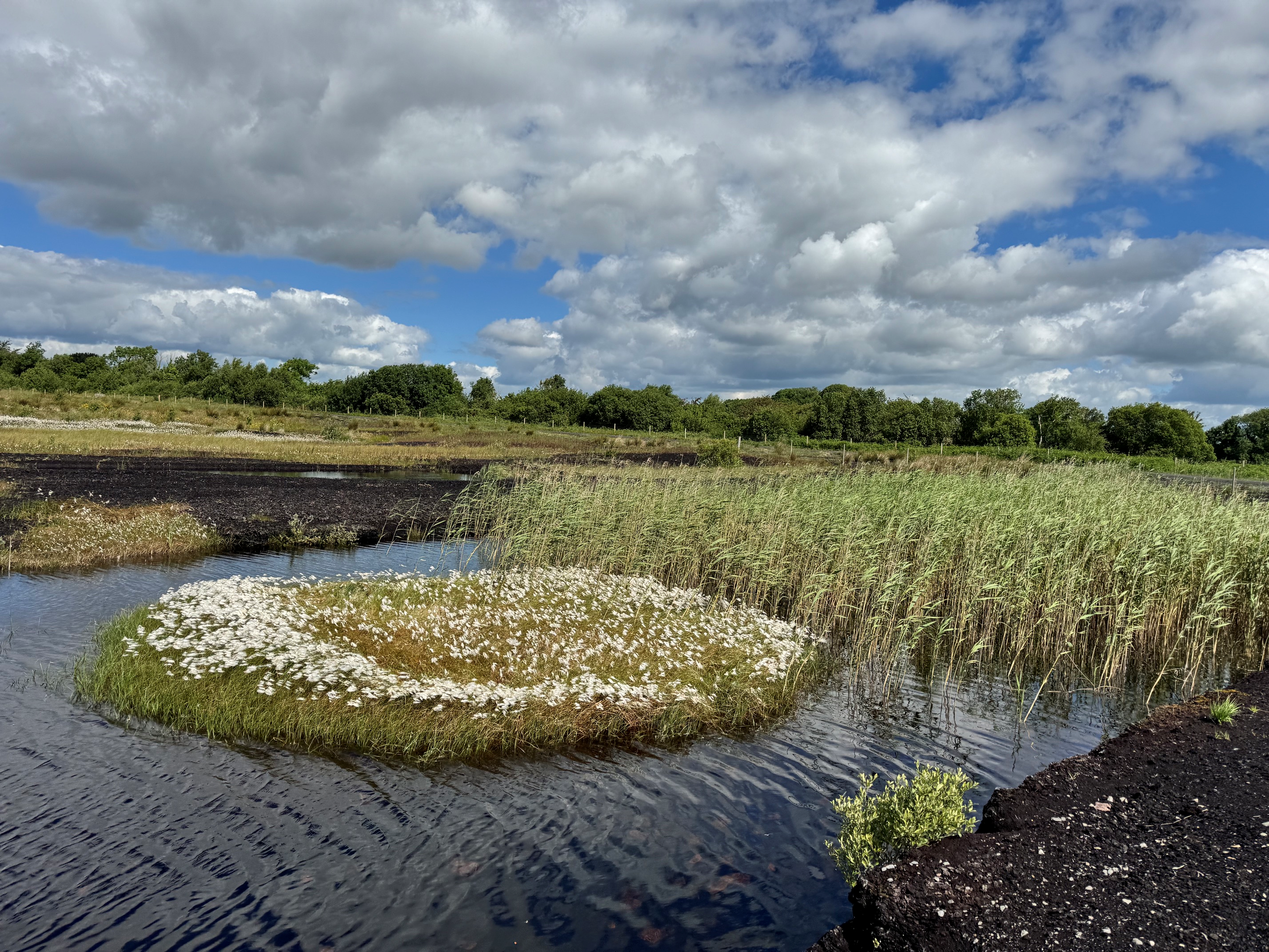
Many fine examples of virgin and cutaway bogs are to be found throughout the parish. Here you will find the Curlew, Snipe, Skylark and Herons in quiet meditation beside small water pools. The otter, fox and hares make their homes here. In mid-summer the bogs are a blaze of colour with cotton, orchids, ragged robin, cranberries, pitcher plant and mosses.
Peat is an excellent material for preserving objects buried over long periods of time, sometimes for thousands of years.
This is due to the acidity of the peat, and a deficiency of oxygen within the peatland environment, which prevents the normal process of decay from taking place.
Finds preserved underneath peatlands include
Prehistoric farms such as the Ceide Fields (Stone Age) in North Mayo
Lough Boora Campsite (Stone Age)
Clonfinlough Settlement (Bronze Age) in Co. Offaly
The Corlea Trackway, an Iron Age trackway, or togher, near the village of Keenagh in County Longford
Objects hidden or lost in peatlands include:
Bog Butter
Quernstones
Gold Bracelets
Stone Axe-heads
Trackways or Toghers
Human Bodies
Bord na Móna
The Turf Development Board (TDB) was established by the Irish State in 1934 and was transformed into Bord na Móna in 1946.
Bord na Móna was established to develop Ireland’s peat resources for the economic benefit of the State.
Initially the company produced sod peat and later changed to milled peat production.
The peat was used to generate electricity, manufacture peat briquettes and supply the Horticulture industry.
The industrialisation of the midlands bogs and Electricity generation have provided valuable employment to the region for decades.
A shift in Strategy
Bord na Móna has recently announced the cessation of peat production on all of their bogs.
Peat had been extracted from these Bord na Móna bogs under Integrated Pollution Control (IPC) licences issued and administered by the Environmental Protection Agency.
As part of Condition-10 of this licence, decommissioning and rehabilitation must be carried out when industrial peat production ceases.
In line with Bord na Móna’s accelerated decarbonisation strategy, and the availability of government funding, the company has also committed to ambitious enhanced peatland decommissioning, rehabilitation and restoration measures, targeting circa 33,000 hectares in over 80 Bord na Móna bogs.
This strategy has been developed to optimise ecosystem service benefits of peatland rehabilitation and restoration, particularly carbon storage and reducing carbon emissions.
In addition, this will also benefit biodiversity and water (water quality and catchment management), as well as providing space for local communities and people to enjoy the outdoors.
The Peatlands Climate Action Scheme (PCAS) is also referred to as the Enhanced Decommissioning, Rehabilitation and Restoration Scheme (EDRRS).
Sources:
Bord na Móna - A Living History
Taken from: Peatland Utilisation and Research in Ireland, The Irish Peat Society, 2006, P7-12
Teagasc: Peatlands of Ireland
Teagasc siteFrom ESB Archives - see pdf
Source Pleanala.ie
Raised Bogs of Ireland - J.R Cross
https://www.npws.ie/sites/default/files/publications/pdf/Cross_1990_Raised_Bogs.pdf?shem=rimspwouoe
Irish Peatland Conservation Council
https://www.ipcc.ie/a-to-z-peatlands/peatland-habitat-types/raised-bogs/